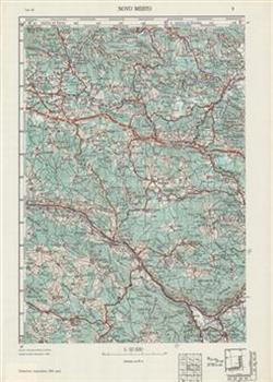
 Topographic map of Yugoslavia for the territory of Slovenia, 1950-1967
State topographic maps at the scale of 1:50.000 are important elements of national cartographic information systems. They are the basis for other maps and thematic cartographic presentations, an instrument for defence planning and for orientation purposes, etc.
Topographic map of Yugoslavia at the scale of 1: 50,000 for the territory of Slovenia comprises 56 sheets printed from 1950 to 1967. The map was made by the Military Geographical Institute of the Yugoslav National Army in Belgrade. The Gauss Kruger transverse conformal cylinder projection and the Greenwich starting meridian were used.